Saturday, September 26, 2009

TWIN FALLS, IDAHO
It was an accidental destination, so you can't blame us for not knowing our way around. We had no idea when we left St George how far we would make it that day, and turns out this was just far enough. An hour outside of town, I was using my phone to google hotels in the area that fit our requirements - a pool, internet access, and under $100 a night.
So we found ourselves at the Best Western (well, after driving the wrong way for a few miles), and chilled out for the evening, long enough to have a swim and too short for dinner.
We had driven across that bridge in the back right of this picture to get into town. In the morning, we wanted to get down here, down by the river that flowed through the gorge right at the entrance to town. We tried several little side street entrances, and kept ending up in neighborhoods with houses that backed right up to the gorge, but no way down. We were peering down, watching the base jumpers going off the bridge, when a hiker came by. I guess she could tell from our bewildered expressions that we were tourists, and even though she did not appear to be a local, she knew the area well enough to tell us how to get to the right road that would lead us down.
She also offered a golden nugget of information that was the best advice we got on our whole journey. She told us about a place to stop along the road where we could get out, climb over the culvert, and take a hidden path up behind a waterfall. That was the most amazing thing. Water splashed down in front of us in a rumbling show of force, spraying us with mist as we walked along a cavernous trail to the other side of the falls and back again. We kept thinking there would be a geocache hidden back here, "and if there isn't, there should be, " says Ted, but we were three miles outside of my "pocket query" (a list of geocaches from a customized search), so I had no idea. We peeked behind the crevices just to see. After we were home, I looked at the map, and I am fairly certain there was not, but there were some in the park down at the base of the hill by the river that I could have gotten.

This waterfall, and the pictures we got from it, was one of the true gems of our journey.

OGDEN, UT
Ted says, "I want to move here"
SALT LAKE CITY
TOUR OF DUTY, by CoolCache
Best (and Only) Geocache we found there
This was probably the best cache find of our trip out west, and I would highly recommend this cache as a "must find" in the Northwest region. Check out the cache page here.
From the description, I thought this would be a fairly straight forward cache on the grounds of the Little America hotel. We parked in the hotel parking lot, but that was not really neccesary, turns out. The cache is actually out at the street level, ten feet from a major road, and very accessible, but awfully well hidden. It took me quite a few minutes to figure out where two large ammo cans would be hidden from everyone's view here.
I had this travel bug to drop off that was sort of special to me, War Bride and Soldier. This travel bug is in dedication to the women left behind in war, like myself.
The cache itself was a dedication to the troops overseas, in particular geocachers who are serving over in the Iraq War. As my husband was leaving for the war ten days after we returned from the trip, it was a "must-do" to find this cache before he left. As you can see, the War Bride travel bug fit the overall theme of the cache, and our trip, perfectly.
In one of hte ammo cans, there is a scrapbook of geocachers serving overseas, in their uniforms and doing the types of operations they conduct on their tour of duties. I am going to have to get Ted's pictures taken to submit for this scrapbook. It was a real honor. A miniature version of the Bradley Fighting Vehicle was attached to the lid of one of the boxes. I was disappointed not to find more travel items in the cache, but I think I traded mine for another. This cache has moved an amazing number (1015) of travel bugs/geocoins.
Then, onwards, we had to get out of Utah before it was too late to make it to Idaho this day.

Sunday, September 13, 2009


GREAT WESTERN ROAD TRIP
Back Country Utah!
And GrandFather Caches
We were finally on the road, feeling the wind through our hair, making great time up the highway towards Salt Lake City. The rate we were going, we would be there by noon....so, we took a detour.
Now, I had been studying this area on the map for a long time. Specifically, I had been trying to figure out if we could get close enough to get a chance at some "grandfather" geocaches, some of the oldest caches hidden. I had been working on a list of the 100 oldest active geocaches, and had stumbled upon a few that weren't particularly too far from the highway we had to take on up to SLC, and on to Idaho.
So, we were making such good time, and were all feeling adventurous, and that is how I happened to earn finds on two of these one hundred oldest caches, Pony Express Stash and Clover Springs Stash.
We found the Pony Express one first, after stumbling upon the right county road, luckily. Here is my log for it:

August 8 by hardings (1620 found)This cache was so fabulous. I grew up loving stories of the old west, and being a horse lover, the Pony Express always interested me. We enjoyed the plaques along the way to this one, and the hike. Was a bit of a tough one for us Texans! Thanks for keeping this one going, it was incredibly awesome to find two grandfather caches today and we enjoyed the history. Left Red Jeep TB.

That was a fun hike, about 0.11 straight up a hill, with prickly desert plants all around. In retrospect, the terrain actually reminded me a lot of Austin. We spent a lot of time exploring the Pony Express station "remains" and plaques. Then we drove next to the Clover Springs camping area, which was about thirty minutes away, if I remember correctly. This time I went by myself to find the cache, which was only about 250 feet from available parking, albeit straight up and devilishly well hidden. Here is my log for that one:

August 8 by hardings (1620 found)We made a side trip just for this one. What an honor to get one of the grandfather caches! It was a short hike, but the uphill about did this Texan in. Actually walked right past it a few times, it was so well hidden, but just right there. Way cool. Thanks for keeping this one alive!

We had so much fun driving through this part of the state. I would recommend these caches to anyone, even those traveling with small children like we were. On the map, it looked like this area would be remote and inaccessible, but it really was not. It is such a pretty area. We had such a good time, but boy, were we famished by this point! (Damned ham sandwich story forthcoming). Luckily, the first town we pulled up into had a TACO TIME! in it - we brake for Taco Time. Turns out too many times on this trip. It's those crisp meat burritos that drive us wild....

-delay in blog posting due to any number of issues, which I hope to correct soon-

GREAT WESTERN ROAD TRIP
St George, Utah...Act 2, in which we ended up going to the Rosenbruch Wildlife Center

We stalked our quarry
Through the forest
While thunder boomed in the distance
and night darkened
The animals flash heads up at us
Appear to come alive
Run, charge, eye to eye
We point at the animal
Angle our weapon at them
Finger trigger presses down
And then that sound,
the polished sound
Of a refined gentleman
Educating us on habitat
And diet, and relationships to others
And we learn what threatens them
Those foreign species
From woods altogether unheard
And now still, in death,
Telling their stories through flesh

Sunday, September 06, 2009

Dinosaur Tracks at Johnson Farm
St George Utah
We ended up taking a two day hiatus on our journey in the little town of St George. This stop was primarily the reason we planned such an extensive road trip, as T wanted to see his grandparents from his (step) dad's side of the family that he hadn't seen in the fifteen years since his dad died.
St George was a nice little town, but the way the streets were laid out was driving me crazy, and resulted in us getting lost, a lot. It should have been very simple. Each street was named with a number and a compass direction. Streets running north and south intersected with streets running east and west, each with a number, usually increasing or decreasing by degrees of one hundred, like 100 W, then 200 W, etc. How could that possibly have been confusing? I have no idea. I think part of our problem was that the street the grandparents lived on was a 40. We would go from 200, to 100, and then the streets would hit the other direction and start going up again, 100, 200, etc. Where the heck was 40? Turns out we were on the wrong side of the highway when we first came into town (my fault), and that the streets started up again on the other side. However, this continued to confuse us the whole time. It should have been an easy pattern to figure out, but the deviations were unnerving. It must have been the work of some Mormom engineer whose brain works completely different than mine.
While we were there, there was a cousin (?) staying there as well who was a few years older than our oldest son. We took him with us on our excursions to discover some of the interesting facets of the town. The Dinosaur Tracks at Johnson Farm Discovery Site was one of those places. In this particular region of the country, many distinct and unusual dinosaur fossils had been found, and were on display at this museum. This included two noteworthy artifacts - the Sitting Dinosaur imprint, and the largest single track of a dinosaur walking that had been found. People come from all around the world to study these historical remnants.
The Sitting Dinosaur imprint is unique because one can see where the pubis bone rested, and the tail as well. It is the only one like this in the world, and has helped scientists understand dinosaur behavior and body use better. There were many different dinosaur footprints at this museum that had been found right in the general area, as well as some other parts of Utah.
As much as our kids like dinosaurs, we learned from our visit here that they actually prefer to see life sized replicas of dinosaurs, and their bones, more than they are interested in their footprints and impressions. They especially don't have the patience to hear us read aloud from the information kiosks why the items we were looking at were unique. Frankly, their interest in the entire place lasted only about an hour, and mostly revolved around the videos playing in one room, the interactive display where they could "search" for dinosaur eggs, and the gift shop.
The best thing about going to this museum was that we earned another geocache find, a special one called an "earthcache", from answering a question about what other kinds of animals left tracks here. This answer was not readily apparent when we walked up, but something we had to keep an eye out for when looking at the exhibits.
I think I found the site more interesting than the children did, but they were very happy with a small token from the gift shop and ready to move on to the next sightseeing stop.

Saturday, September 05, 2009

GREAT WESTERN ADVENTURES
Slow Death of the Pocketbook
It's a small trading post, established 1850, perched at the eastern edge of the Grand Canyon. Two Native Americans sit outside, drinking a soda, and watching the people walk by...into the much larger, modern day trading post next door. filled with several native crafts and tourist type knick knacks, with a deli in the back. There was a virtual geocache at the end of the parking lot, and after spending some time there, I spent an even greater time period shopping inside the doors. Pottery of every type imaginable, with many different textures and colors, lined the shelves, most with steep prices reflecting the degree of craftsmanship. Dream catchers, moccasins, beaded necklaces, furs, and coffee mugs with western designs grabbed the eye. Torquoise necklaces and totem animals gleamed from display counters. Showing economic restraint in the face of such temptation was very difficult. I finally fled the store after purchasing two small vases and a little souvenir for Kaleb (AJ had gotten one at the Grand Canyon store), considering myself very lucky not to have broken the bank in that place.
Then, as we were making our way around the twists and turns of the Marble Canyon area, we saw many little stands, flea market syle, out along the highway, or down a dirt road off to an overlook. Many stood empty, but a fair enough were doing a bang up business out there, selling crafts off the side of the road.
We watched cliffs in the distance come closer, and followed the weave of the road as it struggled to stay next to the winding river. There was a man in an old RV we followed for some time before being able to pass him, with all the curves, and T got frustrated because of the view we could not fully see. We got in front of him just in time to get some nice views of the Vermillion Cliffs, which might have been my favorite spot along the drive.
As the road and river curved steeply to the west, we came upon two very interesting virtual waypoints, The Navajo Bridge and Cliffdwellers. The historic bridge was a sturdy steel bridge constructed in the late 1920s, and had a nice interpretative area and gift shop.
The Cliffdwellers was nothing formalized as that, but a trading post set up in the shade of one of the boulders that had shelters carved into them was doing a booming business, and got some more of my cash. I was hoping now just to get out of Utah so I could stop spending my money on Native American crafts. T kept teasing me about this, since I had been giving him such a hard time about pre-trip budgeting, and AJ kept pouting about things he wanted as well.
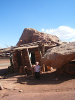
I thought initially that the Cliffdwellers abodes had been inhabited by Native Americans, but the sign nearby one of them told a different story, which I found most interesting. A woman traveling solo by automobile in 1928 had broke down at this location, and was so interested in the property that she bought it, and in the 1930s, invited friends to come live there and turn the boulders into dwellings. So it was a white girl thing after all, who knew? The automobiles at the time were manufactured with the gas tank in a location that would run empty if the cars made their way up the canyon road in the normal fashion, so travelers during that era had to drive their cars backwards up the incline to avoid running out of gas! Based on this information, I would say that woman traveling solo who bought the property sure had a lot of courage.
Both of these places had a great wind factor, and with the air being much drier than we were used to, we kind of wanted to stay inside the car for a while. After a much needed caffeine break, a driver switch, and a couple of pathetic attempts to get some more geocaches on this leg, we slowly made our way into St George, Utah, where we promply got lost.
Personally, I was very glad to make it out of Arizona without losing all my money to the Navajo, and to reach our destination, and a bed. Now, on to Utah's adventures...


VERMILLION CLIFFS

Thursday, September 03, 2009


Great Western Road Trip Adventures:
Grand Canyon Style
As much as I enjoyed the Grand Canyon, I must admit our trip did not go as I planned. There were many things I would have changed, mainly revolving around the interest of time.
For instance, check out our hotel, the Best Western Grand Canyon Squire Inn. It had all these great things to do there with kids (like the Family Fun Center, and bowling), only we were so tired from traveling all day that we did not have the energy to engage in it fully.
Then, when we made it to the Grand Canyon, we spent so much time checking out every overlook along the way (Ted's idea) to the Village that the children were worn out by the time we made it to the line for the Red Line shuttle to go out to Hermit's Rest (my idea). All the geocaches along this side of the park were either scenic virtuals that we could have reached via the Red Line, or lengthy hikes down the trail into the Canyon. Both would have been nice, but the shuttle bus ones would have been the only ones possible with the kids.
We ended up lunching at this diner type restaurant inside the Grand Canyon Village area. The decor included menus from the 1940s and '50s framed on the wall next to us, and we laughed over the prices and the language used (Riding Mounts All Types 1.50/hr). The children each picked out a souvenir, and Ted bought a hat with an elk on it. (Earlier that morning, he had spotted a huge bull elk sauntering across the highway, and had been tripping out on it all day).
We had spent quite some time in a converted studio that now sold souvenirs. I picked up an interesting book in the gift shop, and want to tell my friends about it later, so next time you see me, ask me the story about Glenn and Bessie Hyde, who disappeared in the Canyon on their honeymoon in 1928...
And then we were off, with sleeping kids, around the eastern side of the South Rim and into Utah...
My name is Keely, and I am a Farmville addict.